

GEOREAL spol. s r.o.

DuGIS – mining GIS

DuGIS is a specialised mining GIS for mining companies and the state mining administration. It provides systematic records of data on mining lease areas, mine workings and mineral deposits in line with the Mining Act No. 44/1988 Coll. and its implementing decrees – from 3D records of surface and underground workings to the planning of extraction progress and reporting.

DuGIS – mining GIS

What it is for

Mining GIS for records and extraction planning

A specialised GIS for mining companies and the state mining administration – one platform for records, planning and reporting.

DuGIS is a specialised GIS for mining companies and the state mining administration. It provides systematic management of mining lease areas, mine workings, mineral deposits and related technological structures in line with the Mining Act No. 44/1988 Coll.

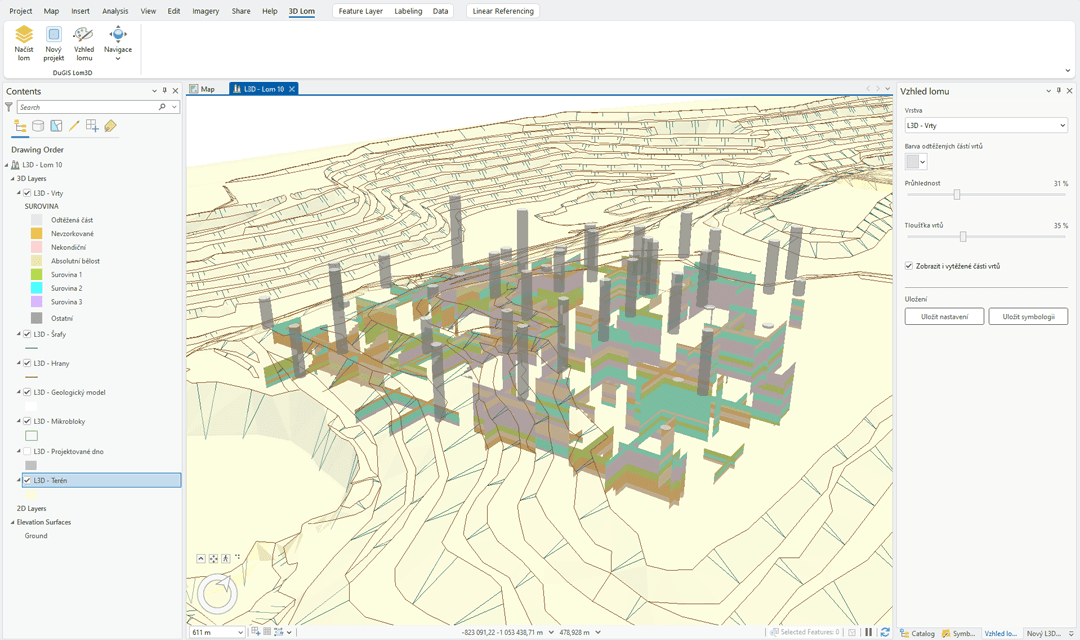
3D records of mine workings

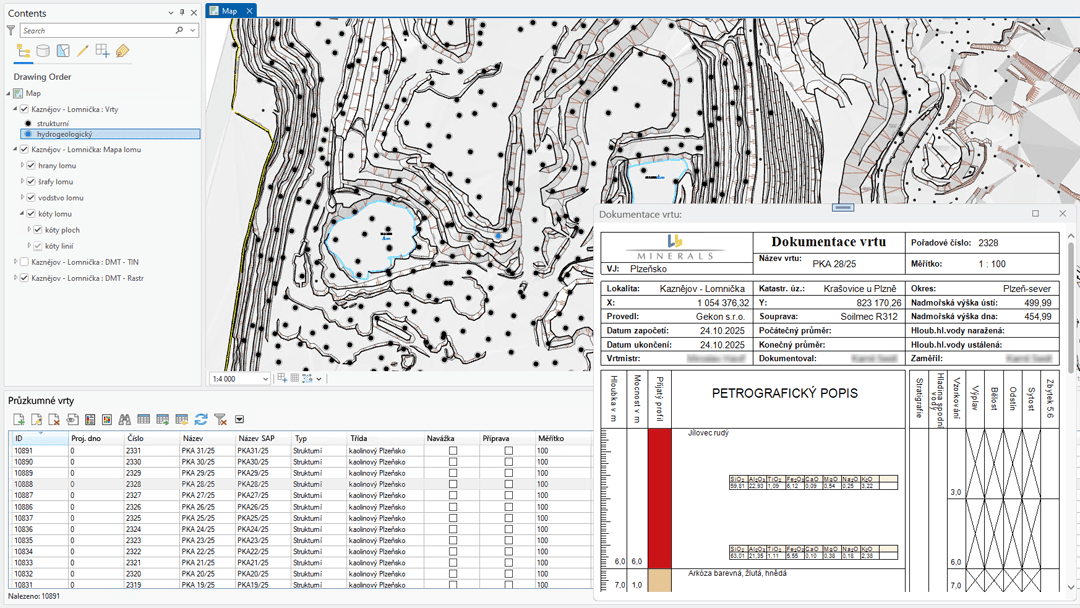
The system keeps three-dimensional records of surface and underground mine workings, linked to mining lease areas and deposits. The mine surveyor works with a ready-made data model for boreholes, excavations, deformation monitoring and quarry maps.

Extraction progress planning and reporting

DuGIS supports the planning of extraction progress, production statistics and the monitoring of reserves, including the generation of detailed source material for plans of opening-up, preparation and extraction (POPD). The outputs meet the requirements of the mining authorities.

Deployment in practice

The system is deployed at major Czech mining companies – both as a desktop extension for ESRI ArcGIS and as a web portal.
Mining GIS for records and extraction planning

Key aspects

Three roles of DuGIS in operation

The three roles that DuGIS fills in a mining operation.

Records in line with legislation

Mining lease areas, mine workings and deposits kept in line with the Mining Act No. 44/1988 Coll.

3D data of the surface and the underground

Three-dimensional records of surface and underground mine workings, linked to technological structures.

Planning and reporting

Extraction progress, production statistics, reserves and the generation of POPD plans in one place.

What you gain

Specific outputs

DuGIS licence

A desktop application for mine surveyors as an extension for ESRI ArcGIS.

Mining data model

Ready-made structures for boreholes, excavations, deformation monitoring and quarry maps.

Reports for the mining authorities

Reports and plans in the formats required by the mining authorities.

How it works

How deployment works

We adapt the deployment of DuGIS to the size of the operation and the state of the existing records.

  1. 01

    Analysis and preparation

    We map the existing records, the data sources and the requirements of the mining authorities.

  2. 02

    Configuration and data migration

    We set up the mining data model and convert the existing data into DuGIS.

  3. 03

    User training

    We train mine surveyors and system administrators directly on your data.

  4. 04

    Operation and support

    Long-term technical support, updates and development of the system in line with legislation.

Numbers that speak

What we do in practice

44/1988 Coll.

compliance with the Mining Act

3D

records of the surface and the underground

2 versions

ArcGIS desktop + web portal

POPD

generation of extraction plans

Common questions

What you ask us most.

For mining companies and the state mining administration – wherever systematic records of mining lease areas, mine workings and mineral deposits are needed in line with the Mining Act No. 44/1988 Coll.

DuGIS comes in two versions: as a desktop extension for ESRI ArcGIS for mine surveyors and as a web portal for sharing data across the organisation.

Yes. The system keeps 3D records of surface and underground mine workings, including the links to mining lease areas, deposits and related technological structures.

We start with an analysis of the existing records and data sources, followed by configuration of the data model, data migration, training and long-term support. We adapt the scope to the size of the operation.

We will gladly demonstrate DuGIS and discuss deployment in your operation.