GEOREAL spol. s r.o.

Volume calculations

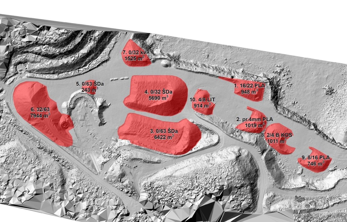
We survey and calculate the volumes of material gained and removed – reserves of raw material and other materials, overburden, stockpiles and earthworks on construction sites. We measure mainly by terrestrial laser scanning, aerial photogrammetry and drones (unmanned aerial vehicles, UAVs), so the result covers the whole area and can be independently verified.

TLS + photogrammetryDrones (UAV)Difference modelsCalculation report
Volume calculations

What it is for

Volumes you can rely on

Accurately determined volumes are the basis for stock records, invoicing, the calculation of payments and checks on earthworks in progress. Instead of estimates, we deliver a figure backed by measurement.

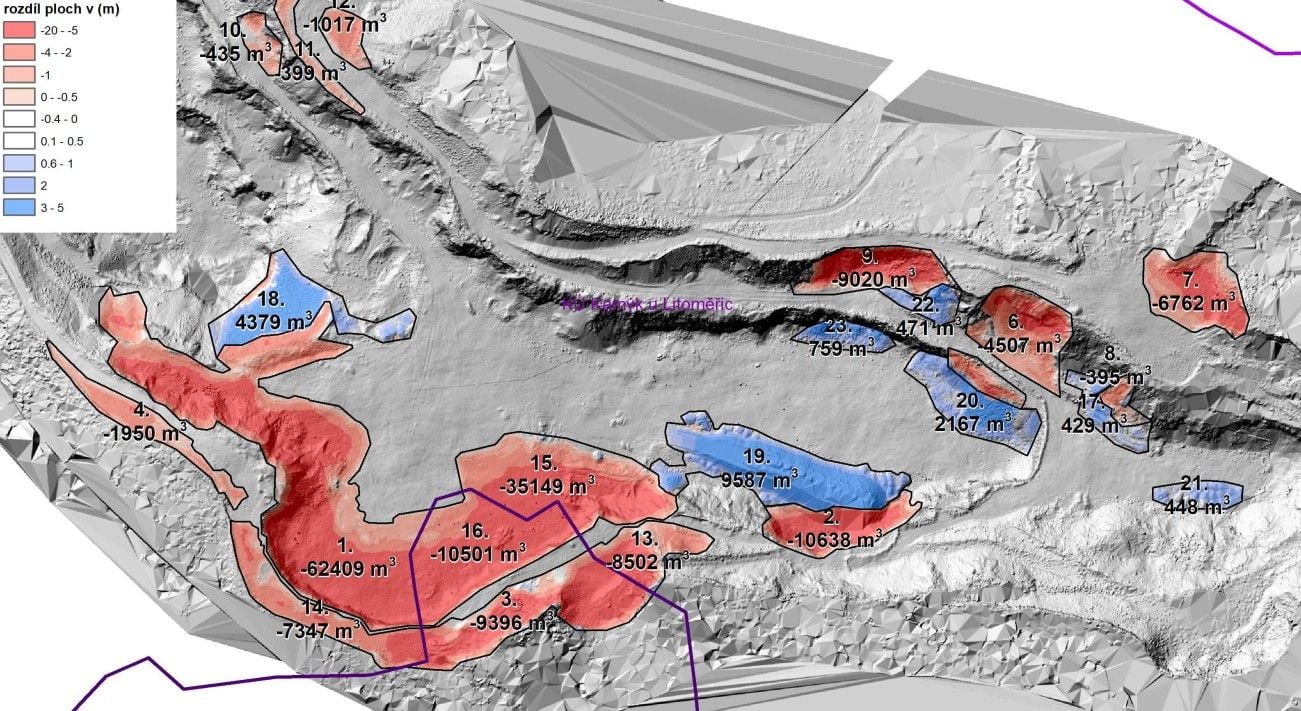
We survey the site with state-of-the-art technology – primarily terrestrial laser scanning and aerial photogrammetry, and a drone at smaller sites. A dense point cloud yields a faithful 3D surface model, which we compare with the previous epoch, the design state or the original terrain. The delivery also includes 3D visualisation and presentation of the data.

The main result is the volume of material gained or removed, calculated over the entire area and not just in a few cross-sections. The handover includes a clear report documenting the calculation procedure, so the result stands up in an audit or in negotiations with a business partner.

Repeated measurement in epochs gives you a continuous overview of extraction progress, the state of stockpiles or the amount of earthworks completed.
Volumes you can rely on

Typical tasks

Where we calculate volumes

  • Raw material reserves and extraction progress in a quarry

  • Volumes of overburden and spoil dumps

  • Material stockpiles and intermediate stockpiles

  • Earthworks on construction sites – cuts and fills

  • Sediment volumes in water reservoirs (sonar)

  • Check re-surveys for audit and invoicing

Deliverables

What you can receive

Volume calculation report

A verifiable calculation of volumes including a description of the method and the input data.

PDF

3D surface model

An up-to-date model of the site as a basis for further epochs and for planning.

TIN / GRID

Difference model

A colour map of gains and losses between epochs or against the design.

GeoTIFF / PDF

Point cloud

The complete measured data for your own further processing.

LAS / LAZ

Site orthophoto

An up-to-date image of the area from a drone or an aircraft for visual context.

GeoTIFF / JPEG

How it works

From brief to report

  1. 01

    Brief and choice of method

    Depending on the size and character of the site we choose scanning, photogrammetry or a drone.

  2. 02

    Field measurement

    We survey the site without disrupting operations – typically within a single day.

  3. 03

    Calculation and checking

    From the point cloud we build a surface model and calculate volumes against a reference surface.

  4. 04

    Report and handover

    We hand over the report, the models and the difference maps, and agree any cycle of further epochs.

Common questions

What you ask us most.

Laser scanning and photogrammetry capture the surface in millions of points, so the calculation covers the whole area – unlike conventional cross-section surveying, which interpolates between the sections. The resulting accuracy depends on the method and the character of the surface; we always describe the procedure in the report.

It depends on operational needs – monthly, quarterly or annual epochs are common. Repeated measurements against the same reference surface give a consistent time series.

Yes. We survey the beds of reservoirs and watercourses with sonar (bathymetry) and combine the result with data from field measurement – typically to determine sediment thickness.

Have a project where this fits?

Contact an expert

Ing. Tomáš Vybíral, Ph.D.

Ing. Tomáš Vybíral, Ph.D.

Team leader

3D scanning and mine surveying
Volume calculations | GEOREAL